Tuesday, January 31, 2012

Hunters Hill- A Closer Look

In October 2011, we did a Jacaranda Cruise as part of the celebrations of Hunters Hill Sesquicentenary of becoming a Municipality in 1861.

That day we cruised the foreshores of Hunters Hill along the Lane Cove and Parramatta Rivers. Today we did a heritage walking tour to discover up close some of the rich history of Hunters Hill.

Of particular interest were:

Vienna Cottage, the National Trust property at 38 Alexandra Street. This stone cottage built in 1871 was the home of John Jacob Hellman and his wife Ann O'Donnell and their six children. John was a shoemaker by trade and came from Hamburg in Germany. Ann, an Irish bounty migrant, came from Mooneenreave, County Leitrim, Ireland.
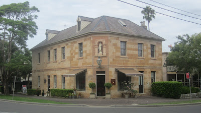


Garibaldi Hotel, on the corner of Alexandra and Ferry Streets. This was Hunters Hill first hotel built in 1861 by Italian immigrant and local businessman, John Cuneo. It was named after the Italian patriot Giuseppe Garibaldi (1807-1882) who fought for the liberation and unification of Italy. It is a golden stone building with a classical Italian sculpture in a niche above the door.

History Services NSW in its Hotel and Liquor Licenses Database has a listing of the various publicans of the Garibaldi Hotel during the period 1865-1900.

First official Post Office at 23 Alexandra Street, Hunters Hill. This was in operation between 1879-1891 when the Postmistress was Miss Twentyman.


Current Post Office, at 32 Alexandra Street, diagonally across from the original Post Office. It is a heritage building built in 1891 as designed by the government architect, Walter Liberty Vernon, in Queen Anne Style. It is listed on the Register of the National Estate.

History Services NSW in its Government Contracts and Contractors Database has details of several contracts awarded by the Department of Public Works for building and repairs relating to the Hunters Hill Post Office in 1890s.

The Priory at Tarban Creek. This site was first used as a mixed farming establishment in 1836 by Thomas Stubbs. In 1847 he sold the farm to the French missionary order of the Society of Mary (Marist Fathers). They used the farm, buildings and gardens as their first base in Australia and as a rest and recuperation facility for their missionaries stationed in the South West Pacific. In 1857 the Marists extended Stubbs original sandstone farmhouse under the architect, William Weaver. They named the site "Villa Maria"

In 1864 when the Marists moved to the opposite side of Tarban Creek, the property was purchased by Thomas Salter who built on a gothic style and renamed it The Priory.

In 1888, The Priory became part of Gladesville Hospital. The surrounding land was farmed by the patients for the production of fruit and vegetables for hospital use, and in the Second World War an air raid shelter was cut into the terrace.

Church of the Holy Name of Mary, Mary St, Hunters Hill.

The original foundation stone of the church was blessed by Archbishop John Bede Polding on 12 Septmeber 1867 and laid on the 15 September. The church which is now the centre of the Marist Fathers Headquarters in Hunters Hill, was blessed and opened by Bishop Louis Elloy SM on 12 November 1871.
Our daughter was married in this church in 2003.

Thursday, January 26, 2012

Lord Sydney and The Convict Arrow


What is the origin of the convict broad arrow that is such a familiar symbol in our convict history?

Andrew Tink in his recent book, Lord Sydney [the life and times of Tommy Townshend] (Australian Scholarly Publishing Pty Ltd 2011), explains that broad arrows (pheons) were used by Lord Sydney's ancestors, Algernon and Henry Sidney in their family coats of arms. Henry Sidney, 1st Earl of Romney, was Master-General of Ordinance (1693-1702) in charge of government supplies. He introduced the use of the broad arrow heads to mark all government property in the United Kingdom.

And so with the decision to transport convicts to New South Wales, the broad arrow was exported on convict property providing a significant, if incidental, link to Lord Sydney's family.

Congratulations to Andrew Tink for his book on Lord Sydney, providing us with a fascinating biography of the person for whom our great city of Sydney was named.

Lord Sydney was Home Secretary in the British Government at the time of the passage of the Transportation Act of 1784. He was responsible for overseeing the logistics of the venture to send convicts to Botany Bay.

Had it was not for his wise choice of Captain Arthur Phillip to command the First Fleet and for his diligent planning of the outfitting of the Fleet, our destiny may have been very different.

If you are interested in Australian history or are researching a convict ancestor, go to our web site at: http://www.historyservices.com.au/

Tuesday, January 17, 2012

Meadowbank and the Ryde Riverwalk

Today we explored Meadowbank, New South Wales on foot. Being the site of both river, road and railway crossings of the Parramatta River, this area is rich in colonial history.

Starting from the Meadowbank Wharf, we did part of the Ryde Riverwalk south along Shepherds Bay.

Immediately we came across an historical photo of the area (at left below), of a ferry leaving Ryde Wharf, circa 1910-1915. This is contrasted with the modern view of Shepherds Bay today (photo at right below) looking back towards the railway bridge.


Shepherds Bay was named after James Shepherd, a convict who arrived in the Colony in August 1791 (per the Matilda). In 1795, he married Ann Thorn who had arrived in October 1794 (per the Surprise). Both had received land grants in the vicinity of modern day Meadowbank. [See below for details of the records held by History Services NSW on James Shepherd and Ann Thorn].*

The first rowing boat service across the river was established as early as 1794 as the Shepherds Bay Row Boat ferry service from Schooners Wharf (Belmore Road, near Helene Park) to the Concord shore. The three wind vane "boats" at the Ryde Wharf Reserve theme this early maritime history

A wharf at the site of the present day Ryde Wharf was completed in 1863, although it was not used by passenger ferries until 1866. This was the hub of transport services to Ryde until the coming of the railway in 1886. **

We then continued on over the present day Concord Road bridge (on the northbound traffic side - photo at right). This was the original road bridge opened on 7 December 1935 by the New South Wales Premier, Sir Bertram Stevens.*** Before this was constructed, a vehicular punt crossed the river just downstream from the railway bridge. An adjacent bridge to the east was completed in 1988 to carry southbound traffic.


The return journey from the southern side of the river at Rhodes is via the original railway bridge which is now a pedestrian and cycle way (opened in April 2000). It is fascinating to be up close and personal to the old steel truss bridge supported by cast iron pylons (photo at left).

This bridge was the work of the great NSW railway engineer, John Witton and was opened in 1886 as part of the main northern railway line. It was replaced in 1980 by a steel beam and concrete bridge which was called the John Witton Railway Bridge.****


******************************************************************
Points to note:

*History Services NSW has records for James Shepherd of his conditional pardon, land grants, marriage and death, in the Convict Database at: http://www.historyservices.com.au/convicts.htm

and details of certain colonial petitions that he signed in the Local Government Petitioners Database at:

For Ann Thorn, History Services NSW has records of her land grant, marriage and death, in the Convict Database at:

** History Services NSW has a record of a government contract granted to a J Nightingale in connection with the construction of a,public wharf in Ryde in 1879, in the Government Contract and Contractors Database at

*** Refer to the History Services Blog, Conscript Pass and Lorna Brand of 25 April 2011.

**** Refer to the History Services Blog, John Witton and the Lapstone Viaduct of 24 September 2011.


Tuesday, January 10, 2012

Cape Three Points


Cape Three Points! What an interesting name. We have a friend who lived in Cape Three Points Road at Avoca on the Central Coast of New South Wales. But what is the origin of the name?


On 7 May 1770, Captain James Cook sailed along this part of the NSW Coastline, past Broken Bay. Looking back southwards, he described in his journal "some pretty high land which projected out in three bluff points and occasioned my calling it 'Cape Three Points' ".


The three points sighted by Captain Cook were Bulbararing Point with Tudibaring Head (First Point) overlooking the present day Copacabana Beach [Photo top left]; Mourawaring Point at the southern end of MacMasters Beach (Second Point) [Photo top right]; and Bombi Point in the south in the Bouddi National Park.

We visited Copacabana Beach today and climbed to the top of the Captain Cook Lookout which gives a panoramic view of the Pacific Ocean.

It is certainly interesting to explore the history of a place.

The first land land grant of 600 acres in the area was made in 1824 to Robert Campbell, a free settler in the Colony. In 1834 this was followed by a grant to John Tooth. Early farmers lived by small scale farming, timber getting and fishing, often with Aboriginal assistance.

Early residents knew Copacabana as Tudiwaring or Judi (often Judi Barn). Other names for this area have been Allagai, Kincumber and Macs.

*************************************************

If you are in interested in early Australian History go to our website at:

Tuesday, November 8, 2011

Pets in Our History

On our visit to Edinburgh last year, we came upon the statue of the legendary Greyfriars Bobby at the corner of Candlemaker Row and George IV Bridge. Bobby, a Skye terrier who spent 14 years guarding the grave of his master John Grey has been dubbed "the Most Faithful Dog in the World" [Jan Bondeson 2011].

A tourist was rubbing the nose of the statue for good luck!

Back home, apart from the bronzed statue of the Boar at the entrance to Sydney Hospital who since 1968 has been enticing us to rub his nose, we seemingly don't have many statues of pet animals in out city. Or do we?

In our search of Sydney monuments we have found some beautiful little statues of our canine and feline friends who have a place in Sydney's history.

Donna, at Central Railway (at left).

Friend and constant companion to John Hogan of Pyrmont, Sydney.

14/2/1975 - 6/5/1995

Recognised in the Guinnes Book of Records as the World's Longest Living Hearing Guide Dog.

Unveiled by the Hon Brian Langton MP, Minister for Tourism on 10 May 1996, to recognise the love and companionship that all Guide Dogs for the Visually Impaired give their owners.


Biggles at The Rocks (at right)

" Loved Friend of the Rocks"

17/8/1980 - 25/4/1994.

A community project, unveiled by the
Hon Robert Walker MLC, Minister for PLanning and Housing on 16 March 1995.


Islay opposite the statue of Queen Victoria at Town Hall, Sydney (at left).

Favourite pet of Queen Victoria.

Died 26/4/1844

The bronze sculpture by Justin Robson (1987) was modelled from a sketch drawn by Queen Victoria in 1842. Now over a century later, Islay is begging hopefully for a coin to help deaf and blind children of New South Wales.


But my favorite of course would have to be the statue of Trim, outside the Mitchell Library on the Macquarie Street side. (at left)

Trim was "Matthew Flinders Intrepid Cat
who circumnavigated Australia with his Master 1801-1803 and thereafter shared his exile on the Island of Mauritius where he met his untimely death".

Flinders in his book, A Biographical Tribute to the Memory of Trim described Trim's features ..."Trim's robe was a clear jet black, with the exception of his four feet , which seemed to have been dipped in snow, and his underlip, which rivalled than in whiteness..."

On the day that we saw photographed Trim the sun was shining on his paws and mouth as if to emulate that image.

*************************************************
If you are in interested in early Australian History or are researching a convict ancestor go to our website at:

Friday, October 14, 2011

In the Footsteps of Mary MacKillop - The Rocks

Our historical excursions around Sydney would not be complete without following the footsteps of Saint Mary MacKillop in The Rocks area of Sydney.

Guided by the book, A Pilgrimage Through The Rocks, Sydney by Sister Jeanette Foxe rsj 2010, we took a walking tour and came upon parts of Sydney that we had not seen before. The Sisters of Saint Joseph had a presence in The Rocks from 1880 to 1901 where they set up Houses of Providence to minister to the poor and homeless. The Jospehites, as the Sisters were known, also taught at several schools in the area.

Like many of the early historical buildings in The Rocks, several of the Houses of Providence and the buildings housing Josephite schools have been demolished and the sites redeveloped.


However two significant "Mary" sites are still standing in Kent Street.

The first is St Brigid's Church (photo of outside at left and interior at right above).

It was completed in 1835 under the auspices of Governor Sir Richard Bourke "as a Roman Catholic School House to be occasionally used as a Chapel". The building originally housed a school for boys started by the Christian Brothers in 1843. The Josephites taught there from 1884 to 1898.

Today it is a beautiful little Church - a rare find.

The second site is Winsbury 75-79 Kent Street (photo at right ). It was the third House of Providence rented by the Sisters of Saint Joseph from 30 July 1880. Mary MacKillop resided there from February -March 1881.

No longer standing is Cheshunt, the fourth and largest House of Providence, at 3 Cumberland Street, now the site of the Harbour View Hotel. Mary stayed here from December 1882-March 1883 and again from November 1883-March 1884. Next door to Cheshunt was the parish Church of St Michael's built in 1882. It was from here that Mary's Mother, Flora MacKillop was buried following her drowning in the shipwreck of the Ly-ee-Moon off Eden, NSW on 30 May 1886.

Another is St Bridget's Hall School, 89-113 Kent Street, now the site of the Observatory Hotel. The Josephites ran this school for girls from August 1880 until it closed in 1886.


For a History of the Roman Catholic Church in the Colony of New South Wales 1800-1836, go to the Resources link in the website of History Services NSW at

Wednesday, October 5, 2011

Thornleigh Zig-Zag Railway - A Discovery

Route of Thornleigh Zig-Zag Railway -1883
An interesting afternoon as we traversed the route of the Thornleigh Zig-Zag Railway. This was the third and last zig-zag railway built in NSW (after Lapstone and Lithgow).

It was constructed in 1883 by railway contractors, Amos & Co, as a branch line coming off the main Northe
rn Railway Line just north of what is now Thornleigh Station and descending to a quarry some 35 metres below. The quarry supplied "stone ballast (white metal - metamorphised sandstone) for a southern section of the Homebush (Sydney ) to Waratah (Newcastle) railway line" [Historic Engineering Marker 2006, Thornleigh Quarry].

The zig-zag facilitated the steep descent/ascent to/from the Quarry for the railway trucks carrying the stone to the top for use along the route of the railway line.

While much of the route of the Zig-Zag Railway has today been taken over by residential development, we followed the descent from the top point across Pritchard and Wells Streets to the bottom point neat Janet Street. Then entering the bush from a track off Morgan Street, we came to Zig-Zag Creek (photo at left above) and then up a little further up to the Quarry (photo at right above). It is a huge excavation site. We climbed to the top just below to what is now Oakleigh Park.


On our way back we were attempting to ascertain the actual route for the Zig-Zag, when we discovered an old railway sleeper embedded near the creek (photo above and at left below). Its position would suggest that it is probably part of the original line.

Also nearby was a piece of narrow gauge rail line. (photo at right).

So at least we were close to the original route which appears to have run close to the Creek.


History Services NSW in its Government Contracts and Contractors database has many entries for railway contracts awarded by the NSW Government for the period 1832-1900.